
- Cisterns (we have a gold coast cistern in data that hasn't been used to date)
- Some of the Stirk trees could be reused here
- Aloe Vera and other Succulents being the predominant plantlife
Region Planning: Northern Goldcoast
Region Planning: Northern Goldcoast
I imagine the northern Goldcoast to be a semi-mountainuous and fairly arid area.

My thoughts:
- About half of this region is currently colored in on the map as the "Gilded Foothills",which would serve as a transit region between the Gold Coast and the Colovian Highlands. Northern Gold Coast assets should be developed with this transition in mind. As noted, these hills are more arid and dusty than the savannah-like south, influenced by the Hammerfell desert.
- Elevation-wise, the entire area is on a plateau when compared to the southern coast. The elevation rises gradually along the western road to Sutch (allowing easy access for the player) but drops dramatically around the area of Lake Oloman, framing the northern shore of the lake with a big ridge. This way, we can naturally situate Sutch in its ravine.
- Another thing this elevation allows us to do is make large, near-vertical cliffs along the seaside. Cliffs haven't seen a lot of use in Morrowind yet, so it should help to make this region memorable and distinct. Also, cliffs along the northern border should discourage the player from traveling further north and falling off the map, so to speak.
- Lake Oloman is mainly used to produce salt. The surrounding shores (except the northern ridge and western access slope) should be very flat, and use special ground textures. This would be a very nice place to situate a couple of cisterns as part of the saltworks infrastructure. It would also be interesting to have some broken-down fishing piers and such some distance away from the lake shore, as if the water level used to be higher. This would give the place some visual history that we don't have to spell out in dialogue or books.
- In terms of vegetation, I agree on the succulents and the wind-bent Stirk trees. In general, the area should be more sparse than the south, with much less grass and fewer trees. To keep the landscape interesting, we could perhaps cross the plateau with little gullies and ravines that are sheltered from the winds, and dense with local vegetation.
- Brena River Fort: an Imperial fort along the upper northern river. From here, a ferry takes trade caravans across the river to Hammerfell. At least, it would if there was a Hammerfell to go to.
- Bleak Mine Excavations: this large semi-open mine is the heart of the saltworks, where many people from Sutch are employed. The mine used to be run as a cooperative by the Sutch merchant houses, but was seized by Oloman when he claimed the city. Today, it is owned by a Colovian nobleman who has a manor a bit to the west. The mine is a target for Kali Mes sabotage.
- Blood Dome Temple: this shrine is owned by the Red Templars, an extremist Talosian cult popular among the Legion's officers. They maintain several such temple domes on places where Tiber Septim shed blood in battle. The shrine lies a bit outside of Sutch proper, but it weighs heavily on the town's politics: if the Emperor were to authorize a Legion action against the Kali Mes, command would likely fall to a Templar officer - and Templars are known to be particularly ruthless in the face of rebellion.
- Sutch vineyards: these lie along the softer western slopes, in sight of Sutch, but away form the saltworks. These produce the local Colo-Redguard wines, like Go-Nogro and Talan's Heritage.
- Mauloch Shrine: hidden somewhere in the cliffsides is a forgotten shrine to Mauloch, dating back to the days of the early Nedes. While Mauloch is not worshiped by any Imperial cult, the shrine's location is of interest to an Orcish party in Anvil, who have been sent from Orsinium to locate it.
- Miscarstette: an old Colo-Nordic ruin on a small island off the main coast, once home to the earliest kings of the Strident Coast. The Shore-Kings governed the Gold Coast for most of the First Empire, before being replaced by the Oloman dynasty after the Thrassian Plague. Local legends see them as Arthurian figures, who will return one day to reclaim the coast in its hour of need. Their keep itself is mostly untouched thanks to the high cliffs that ring the island on all sides.
- Crowhaven: once a prosperous village and fortress, this settlement was destroyed in the passage of the Camoran Usurper. Some part of the Usurper's power remains in the ground, and the dead sleep uneasy here.

Thought a bit about it we could add some more cactus-like plants (like opuntioides [opuntia, quiabentia/pereskia (though, it likes more humid environment iirc, need to check)/pereskiopsis], echinocactus, echinocereus - generally looking like North America cacti which, imho, looks more ferocious than South America ones). I will try to make something like this and show somewhere, maybe in my showcase thread.worsas wrote:Aloe Vera and other Succulents being the predominant plantlife
<ThomasRuz> A cleansing potion, with a nasty side-effect
<rotouns> Drain Spear 50 / 3600s
<ThomasRuz> We shall call it... the potion of impotency!
<rotouns> Drain Spear 50 / 3600s
<ThomasRuz> We shall call it... the potion of impotency!
Some asset guidelines for this area. In general, the northern Gold Coast is supposed to be a transit region between the Gold Coast and the Colovian Highlands. Asset guidelines decided on here should also be used for the eastern region borders. Unique for the northern Gold Coast is its nearness to the deserts of Hammerfell, meaning we are on the border of the Gold Coast savannah biome. In general, we can use (remixed) Gold Coast assets or new assets made with the Colovian Highlands in mind.
- Two or three "salt plain" ground textures for the lake environment.
- Arid earth/sand/sandstone ground textures for the upper Gold Coast. The region is supposed to be a transition from the Gold Coast to the Colovian Highlands, so few if any new terrain textures should be necessary. If neccesary, we could use existing Golc Coast terrain textures and darker them or make them look less green.
- Rocks: cliffs are very important for the Sutch designs and the oceanfront. The current Gold Coast cliffs should do fine, as long as they avoid too much grass.
- Flora: Stirk trees, cacti and succulents. Perhaps one or two extra container plants should be added in the vein of the Aloe Vera. A couple of unique, dry-looking shrubs would also be nice to make a convincing undergrowth in sheltered valleys, ravines and near water sources.
- The saltworks: the industry around the lake can convincingly be depicted using the new, barnacle-less docks set and assets like the cisterns. We could use some salt mounds and beds, like this. The interior of the saltmine will also need something like salt rock containers.
- A Sutch Salt ingredient, looking like a salt crystal or cluster.
- Improved grapevine meshes (+ SHotN's trellis assets)
- Settlements: most places (Thresvy, Seppaki, and the Bleak Mine saltworks) can use the Gold Coast rural Imperial houses. Especially the rural shacks should be used extensively: this is not a wealthy region.
- Sutch: probably the most difficult part of the region, Sutch will need a number of special assets:
- The stone spire itself on which the city is built might have to be a unique model.
- The docks and lower-class houses that cluster around the bottom can all be rural houses like the ones we already have, no big deal.
- The Ascensor/really big medieval elevator will need unique exterior, interior, and elevator parts.
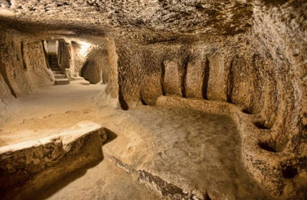
- Sutch interiors should have a semi-unique cave-houses tileset, a bit like Cappadocian underground cities. They should feature decoration and architectural elements inspired by Redguard culture, with a strong African feel.
- The top level of Sutch should consist of a)Anvil houses with some Reguard influences b)new Redguard exterior set c)mix of the two. Maybe based on SHotN's Redguard stuff.
- Walls, gates, and large bridges to span the ravine. We could easily use SHotN's Redguard fortress set for this, with a retex.
- Optionally, some smaller Redguard culture stuff like statues, frescos or ruins to throw around the landscape.
Location map of the western Gold Coast. Couple of proposed names and new locations on here (mostly the Colovian barrows). The northern wilderness should feature a couple of Colovian barrows in the south, and some of the Old Imperial ruins (which we otherwise don't have in the south).
EDIT: uploaded newer version of the map, based on the latest Anvil and Gold Coast claim files.
EDIT: uploaded newer version of the map, based on the latest Anvil and Gold Coast claim files.
- Attachments
-

Minor note (didn't know where to put this) - In Haafinheim, there's a small mining settlement called Dunbarrow. It's Imperial in origin, but was recently seized by King Thian. I don't know if it's an issue that the placename appears in both mods.
"I don't know if you are kidding but I 100% support a Big Mouth Billy Bass in PC"
- Taniquetil
- Taniquetil
Dunbarrow Cove is an original cave name from Oblivion (the thieves den dlc, I think) so I'm reluctant to change it. I don't think the cave will contain any NPCs, so no dialogue errors should occur. I'll make a note to avoid dialogue conditions that mention the location, just in case.
Mystery solved:
http://www.uesp.net/wiki/Oblivion:Cap'n_Dugal's_Journal" onclick="window.open(this.href);return false;I was born in a little town on the north coast o' Skyrim called Dunbarrow. Me mother was a wench and me father was a right bastard. The only thing that either of 'em e'er did fer me was doin' me the favor of sellin' me off to a sea cap'n when I were nine. That cap'n, he taught me e'ry thing I'd e'er need to know about sailin', and a few things about the rest too.
"I don't know if you are kidding but I 100% support a Big Mouth Billy Bass in PC"
- Taniquetil
- Taniquetil
Map update:
- The wip Anvil claim is now indicated in gray.
- Farm names: the three farm houses near Anvil have been designated as Valach Farm, Miris Farm, and Gweden Farm. Valach farm was originally called Whitmond farm, which is not suitably Colovian/Imperial imho.
- Imperial ruin north of Anvil replaced with a 2nd Empire ruin, called Olomachus.
- Added three nameless cave icons along the shoreline of the Sutch release area. Given that this area is conceptualized as a large seaside cliff, it makes sense to drill some cliff caverns in it.
- Added four nameless Colovian tomb locations across the northern map. The tombs closest to Sutch hail from the time when the Colovians ruled the area, and have since been defaced by Redguards.
- Added two campsites close to the northern rive. These would be sites of Redguard nomads/bandits who crossed to river in a Kali Mes smuggling operation. Perhaps fodder for a quest or two.
- Added a ruined modern Imperial fort close to the northern river, called Fort Matillis. Lost during the Usurper's passage.
- Added a 2nd Empire fort icon to the north (38, 115): besides a fort dungeon, this place could also be a ruined village similar to the Crowhaven location. Both of these locations would feature sprawling ruins of what were once prosperous villages, razed during the war with the Camoran Usurper. Classic Old Imperial fort ruins should be appropriate for these.
- Added a 2nd Empire fort icon east of Thresvy. These are the foundations of an old watchtower, detailed in the Thresvy design notes. The tower of Thraswatch was once used to ward against Sload airships.
- Ivrol Estate (46, 120): estate of a minor Colo-Nordic family. They are stakeholders in the Bleak Mine salt excavations. Should play a part in the Sutch/Kali Mes situation.
- Attachments
-

Wow. Someone across forums asked for map, maybe you connect this map with your stirk and kvatch maps and post on main page? This will be awesome!
Thanks, but these maps are a bit too detailed for that: they would become too cluttered and unreadable when merged together. Not to mention that these are WIP maps, so any update would have to be reflected in the main map.
Okay. I understand about wip
No, I think they be really readable, a lot people like detailed maps
No, I think they be really readable, a lot people like detailed maps