Page 2 of 2
Re: Location Map - Workshop
Posted: Mon May 09, 2016 11:11 am
by worsas
Our current
Ordo Legionis also mentions Fort Greenwall, Fort Kastav and Fort Mistwatch.
Also this passage
Further east you will find facilities of recruitment in Fort Helgen at the Pale Pass[...]
obviously contradicts the current location map. We should either fix former or latter.
Neugrad shouldn't be just a legion fort but a town aswell, as it uses a colovian town name. Should be like Pelagiad.
What are your thoughts about adding Dunstad to the southern Haafinheim? It would be good, if Falkirstad wasn't the only 'stad', we have. I don't know, if we couldn't just take one of the two villages for it.
If Northhall is to keep its current name, it should be turned into an imperial or colovian town, otherwise we should nordify it like Granite Hall.
Edit: I have mixed feelings about Blackmoor. Maybe add a branch of the Hjaalmarch between Eldersblood peak and Labyrinthian and have Blackmoor around there? It could be another imperial mining site.
Re: Location Map - Workshop
Posted: Tue May 10, 2016 9:03 am
by arrianas
roerich wrote:Oh, it will be. As high as the engine allows us to. After all, it is the highest mountain in all of Tamriel.
Do you know how high the engine will allow you to go?
Re: Location Map - Workshop
Posted: Tue May 10, 2016 3:17 pm
by worsas
As far as I'm aware ~32,000 is the maximum the vanilla engine can handle.
Re: Location Map - Workshop
Posted: Tue May 10, 2016 10:26 pm
by Scamp
roerich wrote:Oh, it will be. As high as the engine allows us to. After all, it is the highest mountain in all of Tamriel.
Well. Afaik during our timeframe Red Mountain stands to be bigger. Although it will certainly be smaller than Snow Throat in game units, but we don't care. I think we should give 32K a go with Snow Throat, and see how far we can push it.
Re: Location Map - Workshop
Posted: Wed May 11, 2016 12:00 am
by Luxray
Yeah, Snow Throat should be ludicrously huge, as high as the engine will possibly allow.
Re: Location Map - Workshop
Posted: Wed May 11, 2016 4:49 am
by roerich
That Red Mountain is supposedly higher than High Hrothgar is an old misconception still perpetrated by the Imperial Geographical Guild.
Re: Location Map - Workshop
Posted: Wed May 11, 2016 9:03 am
by worsas
There is still the bigger red mountain mod that eviates our problem altogeher. The border mountains are already taller than rm now, which certainly conflicts with lore.
Re: Location Map - Workshop
Posted: Wed May 11, 2016 10:42 am
by Luxray
The spacial-compression effects of the Tribunal's Ghostfence not only contain the dangerous denizens of Dagoth Ur, but also warp height-based geophysics, making the peak look shorter than it actually is.
I wouldn't worry about the height of Red Mountain in relation to any of our mountains. If the border mountains are taller already, we just need to work in relation to those, for those with infinitely long MGE setups.

Re: Location Map - Workshop
Posted: Sat Jun 04, 2016 10:50 pm
by roerich
Uploaded v.04
- Detailing and changes on proposed cliffs
- Added the location of
Kogmenthist Castle ruins at a location mostly true to "steep hills to the south and north of the castle, and east of it lies swamp"
- Minor changes
Re: Location Map - Workshop
Posted: Sun Jun 05, 2016 1:41 pm
by worsas
Good modifications. Good find with Kogmenthist Castle.
Ice and Chitin mentions a number of sites, which should have existed in the second era somewhere along the northern shore of Skyrim.
- Gorvigh Ridge. A mountain range along the northern coast whose cliffs directly lead into the water.
- Nerone. A frozen Isthmus across the bay from Gorvigh Ridge.
- A ruined keep built on Nerone by the Reman Empire, not known by name.
- Porhnak. A settlement or a fortress where apparently some soldiers of the early septim empire were stationed. Somewhere beyond Gorvigh Ridge.
- Danstrar. Probably Dawnstar/Dunstiorr.
http://www.imperial-library.info/content/ice-and-chitin" onclick="window.open(this.href);return false;
Re: Location Map - Workshop
Posted: Mon Jun 06, 2016 6:56 pm
by roerich
Procrastinated a bit from school work and revised the map once again.
Added in the new info worsas posted. I placed the Nerone isthmus west of Dawnstar, and Gorvigh Ridge across from it. I added Porhnak as a settlement on the road towards Dawnstar.
Also changed some roads, cliffs etc. In general a lot of changes.
Lastly I added a layer with hold borders, though I now see that I made a mistake. The area next to Beorinhal which is now Whiterun Hold, should be Falkreath Hold instead. But, enjoy:
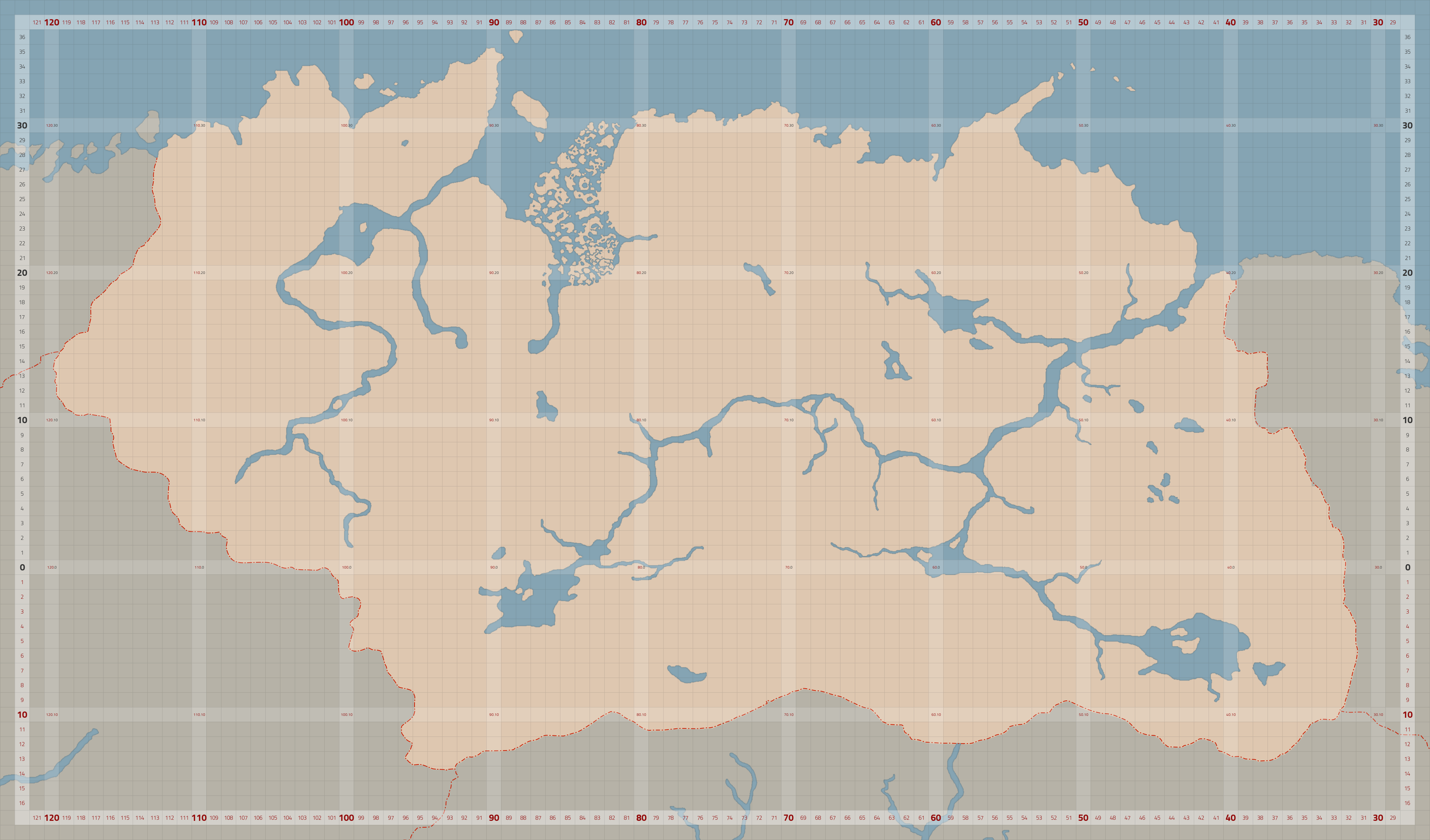
[hsimg=]
http://i.imgur.com/36lZLZL.jpg[/hsimg]
Re: Location Map - Workshop
Posted: Wed Jun 15, 2016 8:29 pm
by Atrayonis
As far as "Workshop" goes, this should fit here. I've made a basemap with bigger, more consistent cell size for SHotN - preview is here:
[hsimg=]
http://www.labofabyll.com/others/SHotN_Basemap%20II.png[/hsimg].
The xcf (layered, with cell exports, and the then latest concept map pasted in in layers) is available
here.
If you want to use it, I can keep adding things to it, snip bigger things from the Gridmap of all Tamriel, whatever you prefer.
Hope you'll find it of use.
Re: Location Map - Workshop
Posted: Thu Jun 16, 2016 9:09 am
by roerich
Incredibly rad!
Re: Location Map - Workshop
Posted: Thu Jun 16, 2016 2:32 pm
by worsas
Thankyou for this nice map. Really helpful for orientation.
Re: Location Map - Workshop
Posted: Thu Aug 18, 2016 7:18 pm
by millysoose
Doesn't PGE say that Red Mountain is taller that the Throat of the World? In Skyrim, I believe they explain that the Throat of the World became the tallest mountain in Tamriel after the explosion of Red Mountain. However, in the context of Morrowind, Red Mountain is still taller.
Re: Location Map - Workshop
Posted: Thu Aug 18, 2016 7:28 pm
by Luxray
Welcome! Yes, that's quite exactly what it says. But in MW gameworld-terms, Red Mountain ingame is really quite small. (For reference the heightlimit is three times higher than RM is), so as per the discussion in this thread, why impose an arbitrary limit, as you'll rarely see Red Mountain from Skyrim lands anyway.
Re: Location Map - Workshop
Posted: Thu Aug 18, 2016 7:47 pm
by millysoose
Yeah apparently I missed the second page of this thread. Someone above suggested the red mountain being the taller of the two is a myth. I rather like this idea. Perhaps this could be explained through an in-game npc, near the base of the mountain.
Re: Location Map - Workshop
Posted: Fri Aug 19, 2016 8:33 am
by worsas
We should not mess with Snow Throat VS Red Mountain - lore at all. The only reason we are exceeding its height is simply that there is otherwise not enough vertical range for us. People can still install the bigger red mountain mod to have this problem addressed.